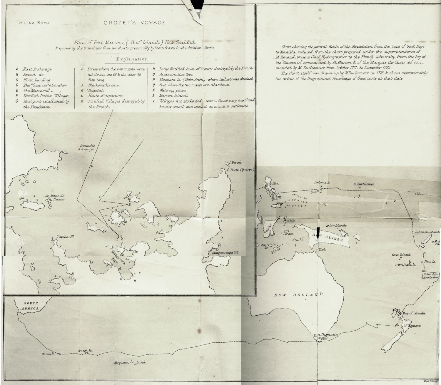
Le 29 au point du jour, nous avons vu la terre sans pouvoir d’abord Ia bien distinguer : nous étions alors dans un lit de marée, dont les vagues saisoient un bruit semblable à celui des brisans. À six heures du matin, nous avons vu clairement la partie méridionale de File Catanduanes, qui m’a paru éloignée de dix lieues. Cette partie de l’ile est haute, montueuse & couverte d’arbres. A sept heures, nous découvrimes la pointe la plus orientale de Luçon, qué les cartes nomment Montasau ; puis la petite île de San-Bernardino, qui me parut aride, garnie de brisans , & qui nous restoit à huit heures au S. S. O., distante de trois lieues. Cette ile est éloignée de Guame de trois cents soixante-dix-sept lieues ; elle est située, suivant mon observation, par 12° 44’ nord, & par 121° 13’ à lest du méridien de Paris. J’y obsèrvai la variation d’un degré N._E. En entrant dans le détroit, nous vimes clai- rement l’ile de Samar, qu ma paru basle, hachée, garnié d arbres, & environnée d’ilots.
Nous ne vimes pas le cap de Spirittos Santo, qui est la pointe N. E. de l’ile de Samar , & qui sert de point d’atérisfage aux galions qui reviennent d’’Acapulco dans la mouçon du 8. ©. C’étoit à ce cap que M. Anfon avoit établi fa croisière contre le galion de Manille qu’il eut le bonheur de prendre en juin 1743.
L’ile de San-Bernardino es au milieu du détroit formé au nord par la pointe S.. E. .de Luçon; le canal a quatre. lieues de ce côté, au midi par le cap: N. O. de Samar ; & le canal, entré le cap & San-Bernardino , eft de cinq lieues Avec les vents de la mouçon du nord; nous entrâmes par le canal du nord en sangeant la côte du Bulusan sur l’ile de Luçon. Les galions qui entrent dans ce détroït dans la mouçon dus. O., pañlent par le canal qui est entre Samar & San-Bernardino.
Dès que nous eûmesdoublé cette pe- üite île, & qu’elle nous resta au S. E., nous trouvämes un Courant qui portoit au S. O. avec tant de force, qu’à peine pouvions-nous manœuvrer le bâtiment. En côtoyant Luçon, nous y vimes à Pouest de San – Bernardino l’établislement de Bulusan, dans lequel je remarquai un grand édifice qui pouvoit être une église , nous déployämes notre pavillon; & dans le moment nous vimeshisser celui d’Espagne. Cette côte présente un as- pet agréable, des anses de sable d’un accès facile, & pluñeurs ouvertures de ruieaux.
À deux heures, nous nous trouvâmes à deux lieues de la pointe septentrionale de Pile Capul. Cette île est pour ains dire la seule dans toute cette route qui porte sond un peu au large. La sonde nous dosna un brasléiage très-inégal pendant lespace de trois lieues : nous trouvâmes de 7o à 35 brasles bon sond: nous ne commençämes à le trouver que lorsque file: Sän – Bernadino nous resta au N. E., à la distance de cinq lieues. Dans le mêmé ‘ternps, les ilots de la pointe de Bulusan nousrestoient auñord, ë& la pointe septentrionale de Capul au sud : noùs perdimes le sond lorsque la même pointe de Capul ñous resta à l est S. E., distante de quatre lieues.
SAN BERNARDINO.
At daybreak on the 29th we made land without being able to distinguish it well; the tide was making and the waves made a noise like that of breakers. At six o’clock in the morning we sighted distinctly the northern part of the island of Catanduanes, which appeared to me to be ten leagues off. This part of the island is high, mountainous, and covered with trees. At seven o’clock we sighted the easternmost point of Luzon, called Montafou on the charts, then the little island of San Bernardino, which appeared to be barren and surrounded with breakers, and which at eight o’clock in the morning was three leagues off to the S. S. E. This island is three hundred and seventy-seven leagues distant from Guam, and according to my observation it is situated in latitude 12 deg. 44′ N. and longitude 121 deg. 13′ east of Paris; magnetic variation was 1 deg. N. E. On entering the straits, we saw the Island of Samar very clearly, it appeared to be low, rocky, covered with trees, and surrounded by islets.
We did not see Cape Spiritto Santo, which is the N. E. point of the island of Samar, where the galleons returning from Acapulco land during the S. E. monsoon. It was at this cape that M. Anson established his quarters for his attack on the Manilla galleon, which he had the good fortune to take in June, 1743.
The Island of San Bernardino is situated in the middle of the straits bounded to the north by the S. E. point of Luzon, and the N. E. point of Samar Island; the channel is four leagues broad here, and six leagues broad between the cape of Samar Island and the Island of San Bernardino. With the winds of the northern monsoon we entered the north channel by coasting along Bulusan, on the Island of Luzon. The galleons which enter this strait during the S. W. monsoon pass through the channel between Samar and San Bernardino.
As soon as we had passed this little island, which we left on our S. E., we encountered such a very strong south-westerly current that we could hardly manage our vessels. In coasting along Luzon we saw to the west of San Bernardino the settlement of Bulusan, in which I noticed a big building which might be a church. We hoisted our ensign, and were immediately answered by the Spaniards. This coast is pleasant to look at, with easily accessible sand coves and several fresh-water creeks.
At two o’clock we found ourselves two leagues off the northern point of the Island of Capul. This island is the only one on the whole route off which we could, so to speak, anchor in the open sea. The bottom for three leagues gave us very unequal soundings, but we found it good at 70 to 35 fathoms, although we did not begin to reach it until the Island of San Bernardino was five leagues to our N. E. At the same time the islands of the Cape of Bulusan were to the N. of us, and the northern point of Capul was to our S. We found no bottom when the same point was four leagues E. S. E. of us.